The Antarctic continent | The Antarctic Ice Sheets | Ice streams, subglacial lakes and ice shelves in Antarctica | Wildlife of Antarctica | Exploration of Antarctica | References | Comments |
The Antarctic continent
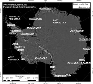
Antarctica: the enigmatic, romantic, remote white continent. Antarctica lies at the bottom of the world and all waters south of 60°S latitude are designated Antarctic, where no country owns the land and where only scientific and peaceful operations may take place. Military activity is banned in Antarctica, and it is a haven for wildlife.
Unlike the Arctic, where floating sea ice annual melts and refreezes, Antarctica is a solid ice sheet lying on a solid continent1. The Antarctic summer is during the northern Hemisphere winter. Antarctica may be remote and isolated, but the dynamics of Antarctic glaciers affect us all.
Antarctica is huge. The Earth’s southernmost continent is twice the size of Australia, and 98% of it is covered by ice. Antarctica is cold (the coldest recorded temperature is -89°C, from Vostok), but the peripheral islands and Antarctic Peninsula may have positive air temperatures in summer.
There is no permanent human population in Antarctica, but around 1000 people, mostly scientists and support staff, overwinter each year. Summer populations can be as high as 5000 (excluding the many hundreds of visitors who briefly visit on tourist ships). The British Antarctic Survey maintains eight research stations and operates many summer field camps each year.
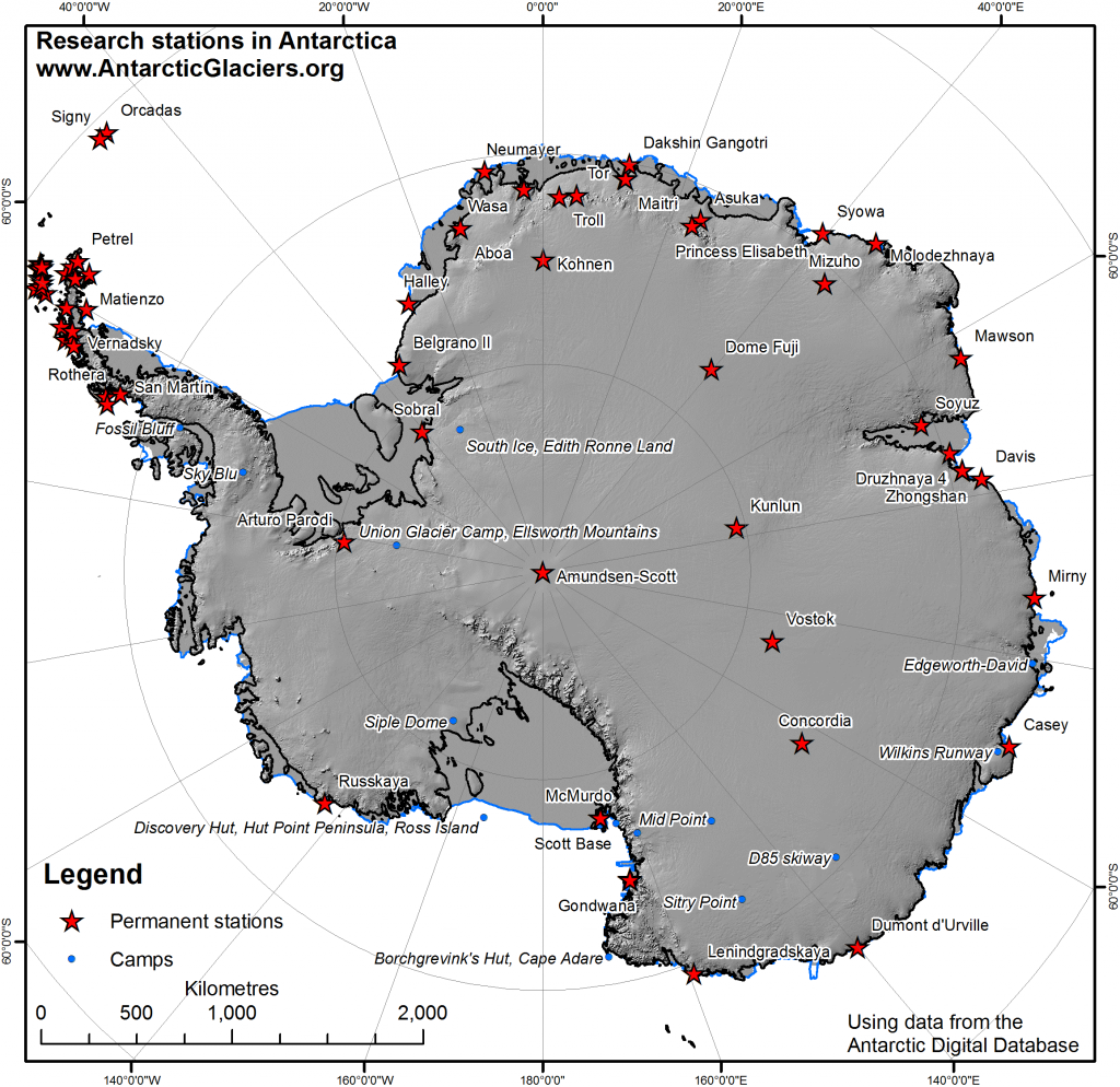
You can use Google Earth to explore Antarctica for yourself. You can see how the great continent is surrounded by cold ocean waters. Note the Antarctic Peninsula, the thin spine of mountains pointing towards South America, the huge flat and floating ice shelves, and the large, high, East Antarctic Ice Sheet.
View Larger Map
Antarctic mountains
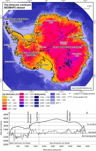
The Antarctic continent lies on a large landmass. Underneath that smooth ice sheet there are mountains and valleys.
The surface of the Antarctic Ice Sheet is up to 4000 m high, and in places the ice is 4000 m deep, but the Gamburtsev Mountain range is up to 2,700 m high and lies underneath the East Antarctic Ice Sheet.
The Transantarctic Mountains divide East and West Antarctica. This mountain range is 3500 km long and 100-300 km wide. The summits of these mountains poke through the ice to form some of the only ice-free areas of Antarctica; these ‘nunataks’ are up to 4,500 m high.
The Transantarctic Mountains contain some of the oldest glacial sediments in Antarctica, and the Sirius Group, from Mount Sirius, indicates that there has been ice here for at least 15 million years. This webpage has beautiful photographs of the Transantarctic Mountains.
You can use the Google Map below to easily explore the Transantarctic Mountains. You can see how they go through the ice sheet. In this map, the Byrd and Shackleton glaciers are in the centre, and they flow into the giant, floating, flat Ross Ice Shelf. How does this compare with the BEDMAP2 figures above and below?
View Larger Map
The first ice in Antarctica grew on the Transantarctic Mountains and Gamburtsev Mountains around 34 million years ago2, when global air temperatures were around 4°C warmer than today. Since then, with on-going cooling, the ice sheets have fluctuated, growing and shrinking at different timescales.
During the Quaternary Period, the ice sheets fluctuated first at 41,000 year timescales, and after around 1 million years ago, they fluctuated at 100,000 year timescales. These huge ice sheets came to dominate and influence the Earth’s climate and global sea levels. The last glacial cycle ended around 11,000 years ago and the Last Glacial Maximum was around 18,000 years ago.

The Antarctic ocean

There is a strong circumpolar circulation around Antarctica. This results in a cooler continent, as heat exchange from the tropics is limited. The circulation in the Weddell Sea brings ice bergs and cold water north, up the Antarctic Peninsula, and is one of the reasons why the eastern Antarctic Peninsula is much warmer than the western Antarctic Peninsula.
Antarctica is globally important, and not just because melting Antarctic glaciers have the potential to raise global sea levels. Cold, salty water forms around Antarctica, which sinks to the sea floor and drives global ocean currents. The Global Thermohaline Circulation drives large currents around the world, and brings the warm Gulf Stream to Britain, moderating its climate.

The Antarctic Ice Sheets
East Antarctic Ice Sheet

There are three ice sheets in Antarctica; the East Antarctic Ice Sheet (EAIS), the West Antarctic Ice Sheet and the Antarctic Peninsula Ice Sheet. Each of these ice sheets has its own unique characteristics and behaviour. East Antarctica is grounded mostly above sea level and forms the bulk of the Antarctic Ice Sheet; if it melted, the East Antarctic Ice Sheet would raise global sea levels by 53 m3.
The EAIS holds the bulk of frozen fresh water on planet Earth, and it’s the highest, driest, coldest and windiest ice sheet in Antarctica by far.
In fact, the East Antarctic Ice Sheet is so cold and dry, it is the world’s most southerly desert. The Dry Valleys of East Antarctica receive around 10 mm of precipitation per year, and the mean annual air temperature is -19.8°C, making this one of the harshest places in the world.
West Antarctic Ice Sheet
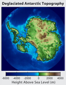
The West Antarctic Ice Sheet is grounded largely below sea level. If it melted, it would raise global sea levels by a mere 3.3 m4, but unlike the East Antarctic Ice Sheet, rapid ice-sheet melt is a threat and a possibility.
The West Antarctic Ice Sheet is grounded well below sea level and the base of the ice sheet deepens landwards; it is therefore known as a “Marine Ice Sheet“.
The West Antarctic Ice Sheet is located in a region of rapid warming, and warm ocean waters threaten to melt the ice sheet at its base5.
During past interglacials, it is likely that the West Antarctic Ice Sheet almost entirely disappeared, and was left as a series of islands – as shown in the figure opposite. A future collapse of the West Antarctic Ice Sheet could rapidly raise global sea levels6. The likely hood of this happening, when it would happen and how long it would take is currently a topic of hot debate7.
Antarctic Peninsula Ice Sheet

The Antarctic Peninsula Ice Sheet is the smallest, holding only 0.24 m of sea level equivalent. However, this small ice sheet, situated on a mountain range, is perhaps the most vulnerable to climate change.
The glaciers of the Antarctic Peninsula are small and located in a region of rapid warming8. This has already resulted in numerous observable changes: collapsing ice shelves9, thinning and accelerating glaciers10-12, and widespread glacier recession13.
Ice streams, subglacial lakes and ice shelves in Antarctica
Ice Streams
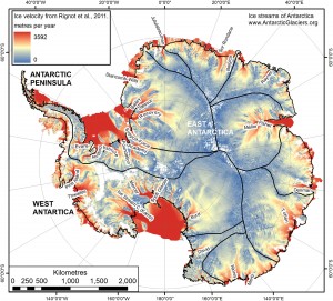
The Antarctic Ice Sheets are not just domes of ice spreading slowly out to their margins. The Antarctic Ice Sheets are drained by fast-flowing ice streams14. The Twaites Ice Stream and Pine Island Glacier, for example, together drain 30% of the West Antarctic Ice Sheet.
Pine Island Glacier moves at about 4000 metres per year, and the stability and dynamics of this ice stream is essential for the stability of the larger Antarctic Ice Sheet. Ice streams send dendritic fingers deep into the Antarctic continent, and you can see on the figure of ice velocities the slow-moving ice divides at the centre of the different ice sheets.
Recent data published by Rignot et al. 2011 shows the ice flow across the Antarctic continent. This image, made from data downloaded from the NSIDC[5] is shown on alogarithmic scale. This emphasises the ice divides clearly. You can see, by comparing with the BEDMAP figure above, that these tend to follow the mountain ranges. Large ice streams drain into fast-flowing, floating ice shelves.
Subglacial Lakes
![379 subglacial lakes have now been identified beneath the Antarctic continent. This map, using data from Wright and Siegert 2012 [1] shows that many are located in ice-stream onset zones as well as underneath slow-moving ice domes.](https://www.antarcticglaciers.org/wp-content/uploads/2013/06/Antarctic_subglacial_lakes-300x259.jpg)
The water ponds in lows and hollows beneath the ice sheet, and it may exist at huge hydrostatic pressure, enabling water to flow uphill.
379 subglacial lakes have now been mapped across Antarctica15, and more are being found all the time. These subglacial lakes influence the behaviour of the ice streams of Antarctica, and drainage of lakes may add more water to the base of an ice stream – helping it to flow faster16.
Ice Shelves
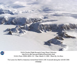
Antarctica is fringed with ice shelves; in fact, 75% of the Antarctic continent is buttressed with ice shelves. Ice shelves are floating extensions of Antarctic glaciers, supplemented by snow fall directly onto the ice shelves and freezing of marine waters below5.
Ice shelves cover ~1.561 million km2, which is similar in area to the Greenland Ice Sheet. Ice shelves collect 20% of Antarctica’s snowfall and cover 11% of its area.
Ice shelves lose mass by melting from below and by calving ice bergs. In fact, basal melting from ice shelves accounts for most of the ice loss from Antarctica, and most of this ice loss comes from a few small ice shelves in West Antarctica and along the western Antarctic Peninsula5.
Sea Ice

Sea ice is seasonal and consists of frozen sea water, together with icebergs calved from Antarctic glaciers and ice shelves. Winter sea ice around Antarctica is increasing, in contrast with winter sea ice in the Arctic, which is decreasing.
This seasonal increase in sea ice may be due to colder, fresher water, released from the melting ice shelves, which accumulates in a cool, fresh surface layer and shields surface waters from the warmer, deeper waters that are melting the ice shelves17.
Wildlife of Antarctica
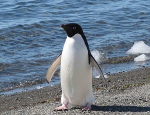
Antarctica is a wild continent. It is also largely deserted; all the wildlife lives in the ocean. It may come ashore briefly, but all the food is in the ocean. Small mites and springtails are the only animals that actually live on the small land oases around Antarctica. Birdlife, however, is prevalent in Antarctica.
Flying birds include Albatross, terns, cormorants, gulls, skuas, petrels and fulmar.
Penguins are Antarctica’s poster child, and Antarctica has seven species: Adélie penguins, chinstrap penguins, emperor penguins, Gentoo penguins, king penguins, rockhopper penguins and royal penguins.
The warm upwelling ocean currents around Antarctica make it a haven for sea animals, and this accounts for the high numbers of Antarctic whales and seals. There are true (earless) seals and fur seals, which have ear flaps.
Whales are common in Antarctica and for decades were hunted, in some cases nearly to extinction. The Antarctic Treaty has allowed some species to recover, although some are still vulnerable.
Exploration of Antarctica
Antarctica was first explored in the 19th Century. Captain James Cook, in the ships HMS Resolution and HMS Adventure, crossed the Antarctic Circle for the first time on 17th January 1773, and was repeatedly beaten back by sea ice. Land was first sighted, probably around 1820. James Clark Ross sailed through the Ross Sea in 1841, and sailed near the Ross Ice Shelf.
Ernest Shackleton lead the Nimrod expedition in 1907 and reached the magnetic South Pole. An expedition led by Roald Amundsen reached the geographic South Pole on 14th December 1911.
Go to top.
Go to top.

Great website!!!!
This is a awesooommmmeeeee website. It’s very neat looking and very well setup.
hi i am going to Antarctica.
Samuel.Furness
Really helpful 🙂
NASA’S Recently released mapping datasets of the Antarctic now show it to be a type of archipelago. With huge areas under ice which are actually below sea level. This revelation makes the actual above sea level land mass significantly smaller than previously realized. Updating your informative web site is now needed
Prove it. 30 million years ago??? Give me a break. You can’t prove jack. Only guessing. Nothing but a theory. You should disclose that.
Penguins are the symbol of Antarctica, and there are seven species: Adélie penguins, chinstrap penguins, emperor penguins, Gentoo penguins, king penguins, rockhopper penguins, and royal penguins.
ANTARCTIC
Now that NASA has released mapping records of the Antarctic, we know that it is a particular kind of archipelago. There are significant areas covered in ice that are actually below sea level. The actual land mass above sea level is much smaller than previously thought, according to this discovery. Update your educational website right away.